Thursday, 19 December 2013

Update December 19, 2013: Cooler nights ahead

Minimum temperature recorded at Panaji on the morning of December 19, 2013 was 17C, which was 4C below normal. Interiors recorded even lower temperatures!

However the day max continued to be 33C at normal.

The humidity in the evening decreased to 48 %, 8 points below normal.

Next few days will continue to see this pattern as E and NE winds blow over Goa. The day temps may drop by 2-3 C.

However north of Goa, N winds are bringing substantial drop in temperatures. Mumbai is expected to reach minimum of 15-16 C. Pune recorded min 7.6 C and Across the Western Ghat Belgaum was in single digit.

Max day temp in Amritsar is now recording 12-13C! And the same is true for Rest of Punjab, HP, Delhi and much of N India shrouded in thick fog over next two days. But light rains in Punjab, HP and Kashmir from approaching Western Disturbance is expected to reduce the fog.

So get set for some pleasant weather in Goa in the early mornings and late evenings!

Thursday, 28 November 2013

Update November 28 - Clear skies ahead!

From Saturday November 23, 2013 weather in Goa saw a dramatic change from earlier few weeks.

Humidity increased rapidly, night temperature and day temperature rose above normal and on November 26 and 27 rains were recorded in parts of Goa. Mainly due to the turbulent cyclonic conditions in the Bay of Bengal.

On November 26, the humidity levels were in 90s, nearly 15% above normal! Margao and Ponda recorded rains between 15 and 20 mm in 24 hr period.


However with cyclone in Bay of Bengal weakened, and dry winds blowing over Goa from the east,
Goa is again heading for lower humidity levels in the coming days.


The Day highs will be in the region of 30-33 C and lows in the region 18-20 C.
 
Winds will be blowing from the east and lower humidity levels should make it a pleasant time to be in Goa!
 

Tuesday, 26 November 2013

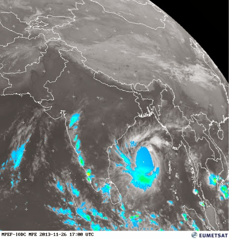
Severe Cyclone Leher brings rains to Goa - November end!

The severe cyclone Leher, currently located at 13 N and 89 E in the Bay of Bengal, is expected to make landfall as Cat 2 or Cat 1 strength cyclone in North AP on Thursday 28 afternoon.

But it's effects are being felt all along the west coast of India including Goa.

Today Tuesday 26th, the humidity was 92% in the early morning and 81% in the evening, representing +19% departure from normal. The Day high was 33.3 C and minimum 22.9 C.

Moderate to heavy rains are now lashing Goa since 9:30 pm.


Satellite imagery at 10 pm IST, showing clouding and rains along west coast of India, including Goa!

The evening rains may continue till the landfall of the cyclone on the east coast and stop as it fizzles over land.

Watch this space for more!

Tuesday, 22 October 2013

Cloudy, Rainy weather forecast from mid week

A rapidly developing low, strengthening east off the coast of Tamil Nadu together with a UAC developing into a low, off the coast of Karnataka and traveling northwards, are expected to together contribute to a fresh bout of off seasonal wet weather in Goa, mid week onwards from Oct 23 to 26th.


The above EUMETSAT image shows the position of the low on East coast as at 3 pm IST on Oct 22, bringing rains to TN and Andra coasts.

The IMD projections for Oct 25th as below, show the east blowing winds and the low centered at 15 N off the coast of Goa. 

This weather system is expected to bring the additional rains to Goa from 10 to 25 mm mostly on 23 rd evening, 24th and 25th.


The SW monsoon has completely withdrawn from the country and the NE monsoon has set. Rains in Goa associated with weather systems of NE monsoons in October are not uncommon.

Expect cloudy weather with occasional bouts of rains with high probability on 24, 25 and 26.

Posting from Chicago, USA, where first snows, freezing are expected on Oct 22!

Saturday, 19 October 2013

Withdrawal of SW Monsoon from Goa - Bye bye Rains, Hello Sunshine!

The easterlies have set in Goa, marking the withdrawal of SW Monsoon from Goa.


The IMD needs 3 days to officially declare the withdrawal, but even the official IMD map on October 19 indicates the withdrawal line at Goa's doorstep.


The days have turned hot, sultry and humid, leading to thunder laden conventional rains in the late afternoon in many parts.

Day Highs are 34C, with a feel of 40C under the sun.

The night Lows are around 24C.

Humidity is in the high 80s.

Late evenings and nights feel cooler, specially after shower bursts.

The weather will continue to remain hot over next few days.

I look forward to some dramatically different climes as I travel to the Mid west and North East US over the next ten days! Cold jet stream moving southwards from Canada is expected to lower the Highs to around 15C and Lows to near freezing in most of these areas. Would I see the first freezing or frost? I'm hoping I do!

Wednesday, 16 October 2013

Finally last gasps of SW monsoons 2013 - thunders a galore!

The SW monsoon is retreating rapidly now. Though IMD has not updated their withdrawal map, as of October 16, conditions in other parts of India indicate that monsoon withdrawal line could be at north Konkan running through MP.


The monsoon axis is shifting southward everyday and the monsoon is expected to withdraw from Goa by early next week.

Heavy thunder activity accompanied by moderate rains was reported from most places in Goa, specially in the interior after 2 pm.

Coastal areas were receiving scattered rains till late evening.

Skies were heavily overcast and humidity was high throughout the day.

Humidity recorded at 08:30 hrs was 89% (+05), and at 17:30 hrs was 88% (+13).

Thunder activity is expected to continue for next few days.

The day temperature is going to remain hot and sultry!

Saturday, 12 October 2013

Current weather in Goa

Rains have been sparse, 'hit and miss' across Goa.

Top rains recorded in the last two days in 24hrs period ending 08:30 hrs are:

Oct 11 - Old Goa - 12.5 mm

Oct 12 - Margao - 14.5 mm

It was dry in majority areas.

Day max temp is around 31.5 C
Night min temp is around 24.5 C

Humidy is in the 90s in the mornings and dew and fog are common at many places.

Humidity reduces into the 70s in the evenings.

A weak trough exists along the Arabian Coast, but rain activity will remain subdued till the depression reaches west traveling from the east.

Friday, 11 October 2013

Severe Cyclone 'Phialin' set to hit Odisha coast

The major typhoon 'Phailin' originating in Bay of Bengal and heading towards the coasts of Odisha and North AP, has rapidly intensified into a Cat 4 and is being classified as 'super cyclone' by IMD.

Core wind speeds are touching 250 kph and intense rains have started in the coastal areas of Odisha and North AP.


The cyclone combined with a UAC central India is expected to activate the trough in the Arabian Sea along west coast, which could bring squally weather and rains in Goa.

Wednesday, 9 October 2013

Goa September '13 Rainfall Analysis - Monsoon Revival!

September 30, marks the end of the official monsoon season, a season which began on June 1!

However this year on September 30th, there is still no sign of the monsoon ending, at least till good part of October. In fact as pointed out in the previous post, there is a revival of sorts of monsoon, which had retreated officially from Rajasthan and NW India. As on date and for the next two three days rains monsoon like rains are expected again in these areas. For a more technical explanation check this video explanation by Rajesh Kapadia in his blog 'vagaries of the weather'

It's no different in Goa!

After the deficient rains in August the trend continued into September and for the first 15 days there was hardly any rains. But then, the rains revived, and with a vigour! The daily September 2013 chart for Margao illustrates the trend as below:


These second half rains have brought the month of September more than the normal rains as recorded for Panaji:


At the beginning of the monsoon season, this post in 'Weather in Goa' Blog had speculated about a few things:

1. Would Valpoi reach 250 inches?
2. Would Panaji (Goa) reach 150 inches?
3. Would Ponda figure in the top 3 places receiving heaviest rainfall?
4. Would Margao get more rains than Panaji?

While Valpoi reached 200 inches on September 30, 250 inches seem out of reach! After the initial excellent rains of July, Panaji struggled to reach 100 inches and did so only due to the late spurt in the rains in September! Sakhali appeared suddenly in IMD's rain centres pushing Ponda to fourth place and YES, Margao finished above Panaji by a large margin!!

So the final seasonal rains are as below:


Thus it appears that it has rained more than 100 inches everywhere in Goa.

Valpoi with the highest and Mormugao with the lowest.

Canacona received the highest rains in September 23.74 inches, followed by Margao at 21.41 inches.


The temperatures recorded during September were as under:

Max Day Temperature : 32.1 C
Min Day Temperature : 27.3 C

Min Night Temperature : 21.6 C
Max Night Temperature : 24.4 C

Average Day Temperature : 30.1 C
Average Night Temperature : 23.5 C

Of course we'll continue to track the rains into October!


Clear Skies, but rains have not gone away yet!

Monday 7th and Tuesday 8th were sunny with clear night skies.

This afforded a great view of the October night skies with a very prominent combination of the 4 day old moon and bright venus high in the south west on 8th.

Crescent Moon and brilliant Venus on the night of October 8, 2013 with the star Antares to the upper left


The bright star Antares in the constellation Scorpius is also visible in the photo above.

On both days there was no rain recorded in any part of Goa.

Day temperature High recorded on October 8th was 31.7C and morning Lowest temperature recorded on October 9th rising to 24.3C.

Humidity is in mid 90s from morning till late afternoon, making it hot and sultry outdoors

Convectional rains with thunder are expected in the afternnon in the state on 10th, 11th and 12th particularly in the interior areas.

The retreat of SW monsoon from N India should resume by tomorrow.

But Goa may see complete withdrawal of the monsoon only in the second half of October.

Sunday, 6 October 2013

Monsoon Lingers ....

The UAC off Arabian Sea has crossed over Goa's coast on Oct 5th evening but not before bringing plentiful rains as forecast for three days.

The rains recorded for 24 hrs period ending 8.30 am at various places is as under:


The June - July like weather which prevailed on these days was a reminder that the monsoon is not yet done with.

The prospects for further rainfall this week has to be seen in the larger context of the meteorological developments over the sub continent.


As seen in the latest satellite image, the monsoon axis is in central India and thunder clouds are seen in this area. There is a high possibility of another UAC forming in the central Indian region and travelling towards the west, in the next 2-3 days. If this happens then the Arabian Sea trough will get activated again, bringing rains along the coast including in Goa.

The GFS meteogram for Goa also suggests the same.


Probability of rains with thunder in the second half of the week exists, but the rainfall amounts could be lower around 10-25 mm.

Friday, 4 October 2013

Weekend prospects

The Arabian Sea monsoon trough became active again west of the Konkan coast south till Goa from October 3 onwards, and is expected to persist till Sunday 6th.


A UAC has also formed in this trough SW of Mumbai


The combination of this trough and the UAC will bring rains along Konkan coast including Goa till Sunday morning. 


The rains are expected to taper by evening of 6th in Goa, with upto 25 mm rains in the interiors.

Sunday, 29 September 2013

Top 24 hrs rainfall figures in Goa from 25th to 29th September

Rainfall has been active over Goa in the week just ended.

The following are the daily maximum rains recorded in Goa in 24 hr period ending 8:30 am for each day from September 25 to 29:

Sept 25 - 20.2 mm at Pernem

Sept 26 - 52.8 mm at Canacona

Sept 27 - 75.4 mm at Canacona

Sept 28 - 12.6 mm at Dabolim

Sept 29 - 20.1 mm at Margao

These rains are typically 'hit or miss' rains!

Today September 30, Panaji recorded 16.9 mm in 9 hours from 8:30 am to 5:30 pm, and interior areas reached much heavier downpours.

The withdrawal of monsoon from NW India has halted and the meteorological circles are buzzing with excitement of witnessing the rare phenomenon of the monsoon re - appearing in the withdrawn areas!

It appears that monsoon will persist with various degrees of intensities till after The festival of Navratri!

Thursday, 26 September 2013

Monsoon revival?

With the low over Gujarat stagnating and strengthening at higher altitudes as UAC, it has not only brought massive rains in Gajarat, but has activated the trough along the west coast from Saurashtra to Goa.


This has resulted in clouding in skies over Goa and west blowing winds bringing in rains since yesterday ( 25th) evening, putting rest to our 'hopes' of good weather for the weekend!

The weather prospects in Goa over the next two days depends on the development of the low over Gujarat. Till it fizzles out, it will continue to pull moisture from the Arabian Sea as well as keep the west coast trough activated.

At present this appears the most likely scenario.

Wednesday, 25 September 2013

Outlook for rest of the week

The phase of continuous daily rains seen from September 16 to 24, is definiitely over!

The low which is still persisting over Gujarat, brought plenty of rains to north Konkan, but Goa was largely spared.

The rains recorded at Margao during last week were:

Sept 16 - 3.1 mm
Sept 17 - 30 mm
Sept 18 - 92.7 mm
Sept 19 - 10.5 mm
Sept 20 - 85.6 mm
Sept 21 - 86.8 mm
Sept 22 - 9 mm
Sept 23 - 12.4 mm
Sept 24 - 20.5 mm

Expect clear blue skies and lot of sunshine during day time rest of the week.

Max day temp could reach 30/31C and early mornings at 23/24C. Humidity would remain in 80-90% range. Occasion mild drizzle should bring relief. Rains could be less than 5 mm per day, mostly towards the interiors.

A perfect time to savor the natural beauty of Goa!

Sunday, 22 September 2013

Rains linger on Sunday September 22

With a low over central India and another in east Gujarat stalled for the moment, the trough on the west coast has become strong again, bringing rain all along the west coast of India.

What this means for Goa is that he rains which were scant on Saturday will pick up again on Sunday.


The winds wil be blowing from the west bringing rains all along the west coast as forecast in models above.

The rains are expected to ease by Sunday night.

Friday, 20 September 2013

Heavy Rains as forecast - Expected to ease over the weekend

Heavy rains lashed all parts of Goa from evening of September 19 to morning of September 20, as expected. The rainfall recorded during 24 hrs till 08:30 hrs on Friday morning was as under:

1. Margao - 86 mm

2. Panaji - 54 mm

3. Valpoi - 48 mm

Most of this rain was recorded in the 10 hours between 9:30 pm on 19th to 7:30 am on 20th.

The rains are expected to ease after Friday over the weekend.

For those interested in numbers, the total rainfall recorded from June 1 till September 20 at rain stations across Goa is as below:


While Valpoi is nearing 200 inches, Panaji has just crossed 100 inches! Margao is nearly 125 inches, though Dabolim and Murmagao are stiil to reach the century mark.
 
 
Margao had 10 'dry' days in September so far. Just 5 days of significant rains as can be seen from the chart below:


Are we seeing the last gasp of a retreating monsoon? Well, while monsson retreat has started from NW India, normally the retreat from Goa is after October 1.
 
But looking at the dim prospects of significant rains in the balance part of September, we may indeed be seeing the last leg of the monsoon this year!


Wednesday, 18 September 2013

Heavy Rain Alert!

Due to persisting strong monsoon trough off the west coast, heavy rains are predicted for Goa and South Konkan by various weather models from September 19 to 21. Rains could be heavier towards the ghats.

Also check out this post by Rajesh Kapadia in his blog 'vagaries of the weather' http://rajesh26.blogspot.in/2013/09/posted-on-monday16th-night-monsoon-axis.html


Monday, 16 September 2013

A wet week ahead?

The latest data put out by IMD for the week September 5 - 11, 2013 indicates deficient rains in Goa and Konkan.


However this scenario is expected to change for the week beginning September 16, as the trough off the west coast has become active again.


The skies will remain overcast and rains will be light and intermittent.

A low pressure area may develop off Goa coast according to some models.


This situation is expected to bring more rains mid week.


However, we will have to wait and see, if these rains are enough to keep the total seasonal rains in the normal range, or inspite of the heavy rains of July we are destined to end the monsoon season with slightly deficient rains!

Wednesday, 11 September 2013

Update September 11, 2013 - Thunderstorms?

As this post is being written, sounds of distant thunder can be heard. The skies are heavily overcast here in Margao since last two days, but very little rainfall. However some other parts of Goa have recorded higher rainfall:

Rainfall in Goa in 24 Hrs ending 08:30 hrs on September 11, 2013:


S.No.
Rainguage
Station
24 Hrs
Rainfall (mm)
Seasonal Total (mm) w.e.f  01st June
1
         Mapusa
002.8
2597.8
2
                Pernem   
 008.2
 3041.6
       3
       Ponda
004.1
3297.9
4
         Panaji
000.2
2462.3
5Ela (Old Goa)000.02901.9
6Sankhali002.23484.4
7
    Valpoi
Trace
4588.0
       8
         Canacona
080.8
  2695.4
9
          Dabolim
024.0
 2378.4
10
         Margao
005.4
2943.1
11
         Mormugao
048.2
2343.1
12
     Quepem
002.2
 2887.7
13
Sanguem
006.0
3783.3


The UAC from east which was expected to enter Arabian Sea through Goa, took a northward route and entered the Arabian Sea through south Konkan, thus sparing / depriving -depending on how you look at it!- Goa of heavy rains! Only Canacona, and areas around Vasco da Gama received heavy rainfall, as seen in the table above.

Panaji is still 3 inches short of reaching the century mark, while Margao has received 116 inches and Valpoi 181 inches.


The second half of September is expected to be wetter than the first half, as the trough on the west coast has become active again.

In the meantime, whenever skies clear Cumulus, Stratus, Altocumulus and Cirrus clouds put on a fantastic array of figures and colourful displays, so typical of September skies in Goa.

Dr Nandkumat Kamat, the noted scientist, sends in a particular formation of Altocumulus clouds, with which his 7 year old son Nachiketas, was so taken up, that he named it as 'Devachim Botam' - God's Fingers.


The CloudSpotter's Guide by Gavin Pretor-Pinney, the founder of the Cloud Appreciation Society, classifies these types of clouds as the 'mamma' cloud formation, named after Latin for 'Breasts', which appear on the underside of different cloud types and often look like a field of udders!
 
More than half of September is still to come, who knows what you'll be able to see in the skies?!


Monday, 9 September 2013

Update September 9: rains delayed?

A sudden formation of an UAC over west Gujarat on September 8, has stalled the westward movement of the UAC near AP coast and consequently heavy rains expected in Goa from September 8 night may be delayed by two days. The rains may skip Goa all together moving into Konkan region if the UAC moves in NW direction instead of W.

This analysis is by the weather blogger Rajesh Kapadia in his latest post in his blog 'vagaries of weather' here

The map prepared by him and available in the post is reproduced below:


Copyright: Rajesh Kapadia 'vagaries of weather'

While the absence of rain will be welcome Ganesh devotees,
 it would extend the present break in monsoon a few more days.

Updates will follow if situation changes


Saturday, 7 September 2013

The Rains arrive for Ganesh Chaturthi - as predicted!

As predicted, the rains reached the shores of Goa, albeit a day in advance!

After Nil or trace rains from September 1 to 6, most parts of Goa experienced heavy to moderate rains since early morning of 7th. Though the rains are expected to ease off during the day on 7th,Goa is forecast to receive heavy to moderate rains from 8th evening to 10th.

As pointed out by blogger Rajesh Kapadia in his blog Vagaries of the weather the trough off the west coast of India from Goa to Kerala has become active due to emergence 
of a low off the coast of TN. This low is expected to move west across interior Karnataka and into Arabian 
Sea off Goa by 9th or 10th. Thus bringing heavy to moderate rains to Goa.

The EUMETSAT image as at 6:30 am on September 7 is as below, clearly showing the activity off west coast.


Thursday, 5 September 2013

Prospect of rains during Ganesh Chaturthi

Ganesh Chaturthi, one of the most popular festivals in Goa and Konkan begins on September 8 and ends on 10th for the majority. People travel long distances to visit their ancestral homes and villages to be with their families, and rain can only play a spoil sport if it makes an appearance.

So far, every day of September has reported Nil rainfall for almost all parts of Goa this year.

However there are synoptic indications that this longest dry spell during this year's monsoon, is about to be broken and the rain may just decide to make its presence felt on September 8 and 9!

An upper air circulation would form over west central Bay of Bengal on September 7, according to IMD forecast and this would subsequently develop into a low pressure area.


It is expected that the off coast troughs along TN coast and corresponding trough along Goa - Kerala coast would remain active and bring rains to these regions.

The rains in Goa could be in the range 10-15 mm, with higher precipitation in the mornings and towards interior Goa.

The Meteogram for Goa COLA/IGES as on date shows this as below:


The S W Monsoons normally start retreating from North west Rajasthan by September 1, though Goa and peninsular India continue to get the S W monsoon rains till around October 10.


The monsoon retreat from N W Rajasthan may have already started as the seasonal low in the N W has increased 1002 hPa from the lows of 994 / 996 hPa earlier in the season.

So, all indications as on date suggest that though it may be overcast with light rain on Ganesh Chaturthi days, it will not be heavy downpour and may be just what was ordered to bring down the rising temperature from around 31C to 29-30C levels!

Happy Ganesh Chaturthi festival to all!


Monday, 2 September 2013

Come September!

The noted Goan scientist, thinker and popular science writer Dr Nandkumar Kamat, has written a great piece on the beautiful facets of nature in the month of September and it has been published by the local daily Navhind Times today on its Opinion Page. Titled as "Experiencing the Magic of September" its available on the net here !

 Any Goan worth his salt will agree totally with Dr Kamat, that with September comes the beautiful sunsets, occasional rainbows, high cirrus clouds against blue backgrounds and all this accompanied by rainy spells with large rain drops and sometimes the fog!

Sunset at Benaulim Beach on September 2, 2013


And the one food item loved by all the Goans starts to arrive in large number in the fish market, with the ban on fishing having ended and the seas calm again for the fishing boats to cast their nets.

Then there is one the most loved of all deities, Lord Ganesha, making his annual appearance in the festival of Chavath. This is a perfect occasion for family members from near and far to gather together and talk of the rains gone by and much more!

With the break in the monsoon continuing into the first week of September, now is the time to step out and experience as Dr Kamat so eloquently puts it "nature's free outdoor photography exhibition"!

Sunday, 1 September 2013

Goa August Rainfall Analysis - Deficient Rains!

After witnessing record rainfall in July, the tide turned 180 degrees in August! The rains were mostly sparse and sunshine was in plentiful supply.

According to the IMD during the month, till 8.30 am on August 2013, Panaji had recorded only 14.19 inches of rainfall, against a normal rainfall of 21.10 inches, a deviation of nearly 35%! In August 2012, Panaji had recorded nearly 26 inches. Thus rainfall in August in Panaji, where IMD maintains historical records, is deficient by nearly 45% over last year!

But inspite of this deficiency, the seasonal rainfall continues to remain above normal, albeit by a small margin, mostly due to the excess rains in July.


The same is true across Goa, with interior areas receiving higher rains than coastal areas.

Valpoi at the base of the western Ghats again topped with 37.31 inches recorded during the month bringing the seasonal total to a whopping 179.91 inches! The top 5 centers continued to be the same as in July, as follows with their seasonal totals:

1. Valpoi - 179.91 inches
2. Sanguem - 147.76 inches
3. Sankhali - 135.35 inches
4. Ponda - 129.12 inches
5. Pernem - 118.96 inches

In fact of the 13 centers across Goa, 10 centres have recorded seasonal rains above 100 inches and only Panaji, Dabolim and Mormugao are still below the century mark!

Perhaps IMD has to seriously think of a new definition for average rainfall for Goa, considering that rains recorded at Panaji do not give the true picture of the rains over Goa!


As usual, Margao gets a special mention here. The daily rainfall recorded at Margao in August 2013 was as under:


There were nearly 18 days in August where Margao received 10 mm or less rains. The wettest day was on 18th with nearly 3.5 inches of rains in 24 hrs.

The Max day Temp: 31C on August 30
The Min day Temp: 26.3C on August 17

The Max night Temp: 24.9C on August 15
The Min night Temp: 22.6C on August 24

Average Day Temperature in August: 29.82C
Average Night Temperature in August: 23.69C

Thursday, 29 August 2013

Will Panaji (Goa) touch 100 inches by August end?

Panaji rainfall as on August 29 has reached 2445 mm, i.e. 95 mm short of 2540 mm i.e. 100 inches! 

So the big question is will Panaji receive around 4 inches of rains in the next two days for the headlines on September 1 to read in bold that the seasonal rainfall in Goa has crossed a century?

This seems highly unlikely given today's conditions.


The low from Bay has fizzled out around west MP. The west coast trough is very quiet. The rains are active generally in Eastern part of India.


Though Goa has been experiencing overcast conditions, it has rained only in traces last two-three days.

No change in outlook is expected, till at least August end.

Hence Panaji will continue to struggle to reach the century mark!

But watch out for Weather in Goa's month end analysis to check out the cities that have already reached the century mark!

Day temperatures will remain around 30C and night temperatures around 24C.

Friday, 23 August 2013

August 23 - What's in store for the coming week?

Last week, it rained everyday in Goa. Heavy rains on Saturday 17 and Sunday 18 tapered off slowly as the week progressed. It looked as if the rains were trying to compensate for the poor performance in the first half of the month. While it rained more in the interior, coastal Goa was also not far behind, as seen from the daily chart for Margao over the week gone by:


August by far has always been less wet than June and July and this year is no exception. The chart below for monthly rainfall till August 23, brings this out very clearly.


For Panaji, 21.10 inches of rains in August is considered normal. Thus till August 23, we have had only 60% of normal rains in August. However due to the super performance in July, the rains are still 6 inches above normal overall.

So what does the monsoon have in store for the coming week?

As seen in this EUMETSAT image on August 23, the weakened low has traveled to Gujarat- Rajasthan from the Bay of Bengal. It has pulled in the moisture from Arabian Sea too, resulting in rains over Sindh in Pakistan and coastal Gujarat. But over Goa and Konkan humidity is expected to fall over the next week.


Thus in absence of any activity of the monsoon trough along the west coast, rainfall is expected to further decrease in the coming week. Sky may remain overcast with a few intense showers, but rainfall along the coast should be between 10-20 mm in the first few days of the week, reducing further towards end of coming week. The interiors should receive a little higher rainfall.


Will update the blog, if there are any new developments.

The hopes of Panaji and consequently Goa (for IMD records purpose), reaching 100 inches mark before August end seems less likely!