Friday 31 July 2015

SWM July 2015 Report - Goa records lowest rains in last three years

South West Monsoons have put up poor performance in Goa in July 2015. The Arabian Sea branch of the SW Monsoons has generally remained less active this year, resulting in a weak off shore trough and poor rainfall all along the west coast of India, including Goa, as pointed out in earlier posts this month.

From June 1 to July 31, 2015 the rainfall departure from normal was -21% for Goa.


During July 2015 the departure from normal was a whopping -28%


While the normal area weighted average rain for Goa in July is 1104 mm, in 2015 July Goa received only 791 mm, which was the lowest in last three years.


Consequently the cumulative rainfall till July 31, was also the lowest in last three years.


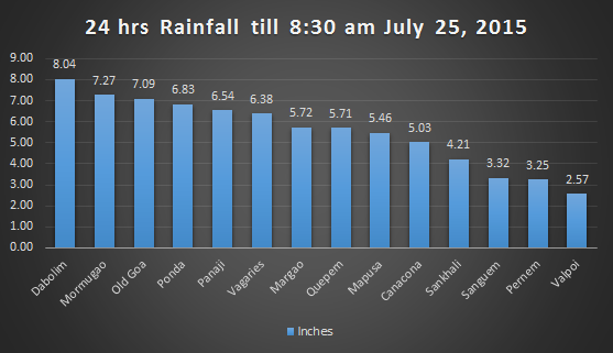
The most significant development was the poor rainfall recorded at Valpoi, the holder of the title of 'the wettest place in Goa' for many years. This year as on July 31, Valpoi had just managed to climb to the fourth spot, overall.


In June the rains were mainly concentrated along the coast, but in July picked up in the interior areas.


Comparing the rainfall during this period in last three years, the striking feature that emerges is nearly 50% less rainfall recorded by Valpoi in 2015 than in 2013. Pernem, Sanguem, Sankhali and Ponda have also recorded significantly lower rainfall this year than in 2013, during this period. However rainfall during 2014 and 2015 are comparable as seen in this graph.


Geographical region wise, Goa presents a mixed result as seen in this map, though normally rains increase as you travel westwards towards the ghats:


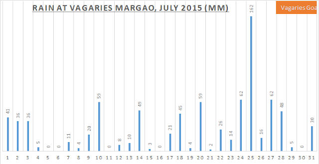
The rainfall graph for Vagaries Goa rain gauge at Aquem, Margao, tells the story of dry days, clear skies and lots of sunshine in July. There were 5 dry days with nil rains and 6 days with rains of 5 mm or less. Heaviest rainfall - 162 mm - was recorded in 24 hrs ending 0830 hrs on July 25.


The day and night temperatures were similar to June with average high at 31.45C and average low at 25C.

The above scenario of deficient rains in Goa till date, fits in with the pan India story of poor rains on the west coast this season, as seen in the map for cumulative sub - divisional wise rainfall for India, released by IMD on July 31, 2015.


The good news is that in spite of this, India overall has received good rains so far, with only -5% deficiency.

A word of caution though: with two more months to go before the SWM season officially ends, this picture can change dramatically!


Rains expected over the weekend - Posted Friday July 31, 2015

Vagaries Goa recorded 30 mm in 24 hrs ending 8:30 am July 31. Most of the rain fell in the early hours.

 Highly overcast at 9 am, with lmoderate intensity rains. As per Vagaries of the Weather blog estimate, rainfall to increase from Friday till Monday in S. Konkan, Goa and coastal Karnataka, due to sectoral strengthening of off shore trough.


Seasonal rainfall recorded at Vagaries Goa till July 31 stands at 1616 mm.

Detailed July report coming up later!

Saturday 25 July 2015

Goa records the heaviest rainfall of the season so far in 24 hours on July 25, 2015

Favourable conditions, detailed in the post of July 24, resulted in the strengthening of the offshore trough, leading to massive rains in Goa in the 24 hours period ending 0830 hours on July 25, 2015.

In the 13 rain gauge stations monitored by IMD and the one rain gauge of Vagaries, 10 had recorded rainfall more than 100 mm and one, Dabolim had recorded more than 200 mm.


The average area weighted rainfall for Goa in this 24 hr period was around 125 mm, which is the highest so far this season. This downpour wiped out 6% off the deficiency figure as can be seen in this chart from IMD Goa :


All the dams in Goa are reported to be near full or over flowing as per this report in Times of India . Reports of water logging, trees falling are coming from all over the state. Fortunately there is no loss of life reported.

For Vagaries Goa raingauge at Aquem, Margao also, this was the highest rainfall recorded in a day this season:


The highest recorded by Vagaries Goa in June this year was 131 mm on June 19th.But the highest recorded by Vagaries Goa in a day in 2014 was 170 mm on July 15, 2014.

The rains of July 24 and 25 also catapulted Ponda to the top of the charts!

Till 8:30 am on July 25, 2015


Friday 24 July 2015

Rains Revive in Goa - the spell may continue into August - Posted July 24, 2015

Under the influence of the revived trough off the west coast, Goa has been receiving medium to heavy rains since the night of July 23. The rains are expected to continue into Sunday and beyond into August, as synoptic conditions are getting favourable for a good spell of rainfall over most of the country.

In 24 hrs ended 0830 on July 24, Margao recorded the highest daily rainfall of 51.3 mm as per IMD, while Vagaries Goa rain gauge at Aquem, Margao recorded 62 mm during the same period. Canacona recorded 44.2 mm and Sanguem 41.6 mm. The area weighted average for Goa as a whole was around 25 mm as per IMD observations.

Check http://weatheringoa.blogspot.in/p/swm-2015-goa-graphs-and-charts.html for daily rainfall figures and seasonal totals, as well as departure from normal rains. As of July 24, the departure from normal this season so far is -26%.

Rains have continued in Margao with same intensity since morning of July 24 and at the time of posting at 1700 hrs, Vagaries Goa rain gauge had recorded 52 mm in 8.5 hours.

As per All India Weather Inference (www.imd.gov.in) issued by IMD at 1130 hours on July 24:
  • A low pressure area has formed over West Madhya Pradesh and adjoining East Rajasthan
  • The axis of monsoon trough passes through Jaisalmer, centre of low pressure area, Sagar, Umaria, Hazaribag, Santiniketan and thence south eastwards to northeast Bay of Bengal
  • The upper air cyclonic circulation over West Rajasthan & neighbourhood has merged with monsoon trough
  • The upper air cyclonic circulation over Saurashtra & Kutch and adjoining northeast Arabian Sea persists
  • The upper air cyclonic circulation over north Chhattisgarh and adjoining Jharkhand & Odisha persists
  • A fresh upper air cyclonic circulation is likely to form over north Bay of Bengal on 25th
All this augers well for both Arabian Sea and the Bay of Bengal branches of the S W Monsoon to remain active over next few days, bringing good rains not only to Goa but to most of Indian Sub-continent.

July 24, 2015

July 30 projection by IMD using GFS 
The weather blog Vagaries of the Weather in its latest post, which you can read in detail by clicking on this link , has given an easy to understand graphical representation of the current weather scenario and projections for Sunday July 26:


Based on this: expect average 30 - 40 mm per day rainfall in Goa till July 26. Many spells during the day could be heavy, and many areas could receive more than 40 mm rainfall. Of course there will be breaks in between and skies may occasionally clear.

In all probabilities and as per various models, these rains may also continue further into next week. Whether with higher intensity or lower intensity, we shall examine in a subsequent post! 

Monday 20 July 2015

Heavy Rains on July 19 but Sunshine on July 20, 2015!

Monsoon rains lashed Goa on Sunday July 19, particularly pouring down afternoon , evening and night with the heaviest rainfall so far in July this year and the third highest since June 1, 2015.

Area weighted average rainfall recorded for Goa in 24 hrs ending 0830 hrs on July 20 was around 90 mm, compared to around 120 mm and 100 mm recorded in 24 hrs on June 20 and 19 respectively.

Six Rain Centers received more than 100 mm of rain during the 24 hrs ending 0830 hrs on July 20:

Ponda: 183.3 mm
Old Goa: 147.4 mm
Valpoi: 142.4 mm
Mapusa: 136.4 mm
Sanguem: 133.5 mm
Sanquelim: 126.6 mm

Vagaries Goa rain gauge at Aquem, Margao recorded 59 mm.

With these rains the Deficiency in seasonal rains came down to -24% from -28% on July 19.

However any hopes of sustained rains were dashed, when clouds cleared by 9 am on July 20, to gave way to bright sunshine and blue skies confounding all forecasts. However rains are reported south of Goa, along Coastal Karnataka and may have just missed Goa. Forecast for rains in the region of 35-45 mm in Goa over next few days stands.

Friday 17 July 2015

Rain activity expected to pick up from Friday July 17, 2015

Rain activity picked up in Goa in the evening of Thursday July 16, and an average rainfall of 20 mm was recorded. This spell is expected to continue and the Blog Vagaries of Weather in its latest post expects Goa to receive around 35 - 45 mm per day from Friday.


The UAC in NW Bay of Bengal and the west coast off shore trough, showing activity in the EUMETSAT image at 10.30 am on Friday July 17, which is beneficial to Goa to some extent.

In the meanwhile, Sanguem became the first Rain Centre in Goa to cross the 50 inches rainfall this season.

The top five rain centres so far are:


The race for the wettest place in Goa for 2015 is still wide open!

Thursday 16 July 2015

Mid July 2015 - Poor performance of Monsoon in Goa

After the excellent rains of June, Goa along with the whole of West Coast of India has performed very poorly so far in July. In the the first 15 days of July, Goa has received average rainfall of just 55.6% of normal, leading to a deficiency of a whopping -44.4% in this fortnight.


A comparison of rainfall received between July 1 to 15 in 2014 and 2015, clearly shows that most of the towns in Goa got 50% or less rainfall this year, in the same period.


However surprisingly, compared to 2014, the situation this year is not much different for the seasonal rainfall from June 1 to July 15. In 2015 the departure from normal is -24% , while in 2014 it was -23%. Click on this post and this post for reports of June 2014 and Mid July 2014.


July normally accounts for nearly 37% of the monsoon rains. A worrying picture emerges this year, because of the -44% deficiency in July so far, making it amply clear that only a spectacular revival in the second half of July and the rest of the season, can lead to normal monsoons this year. Otherwise we are heading for deficient rans in Goa this year.


This year the S W Monsoon has performed very poorly all along the West Coast of India.


Saurashtra (-21%), Gujarat Region (-52%), Konkan & Goa (-27%), Madhya Maharshtra (-30%), Marathwada (-44%), N. I. Karnataka (-32%), Coastal Karnataka (-26%) and Kerala (-32%) are all in the red, even though the All India Rainfall figure shows a departure from normal figure of only -6%!

For reasons analysed in this post, clearly the Arabian Sea Branch of the S W Monsoons has failed so far, even as the Bay of Bengal Branch and the rainfall from Western Disturbances have resulted in good rains for the N and NW parts of the country.

Though the latest satellite image of July 16 is not very encouraging for west coast of India, as per the analysis of the blog Vagaries of the Weather, things will look up for Konkan region and the west coast from Saturday July 18.


Statistically, the SW monsoon rainfall deficiency at -24%, this year, at the time of posting this blog on July 16, 2015, is almost same as that in 2014, this time of the year!  However last year, the Monsoon was on the upswing in July, while for July 2015 it is woefully short by -44% so far, and the trough off the coast of Goa, is still weak! But with it expected to strengthen over next few days, as well as the expected favourable developments in Bay of Bengal, let us see if the rains take quantum jump in volume for the rest of the season!

Stay tuned!!

Tuesday 14 July 2015

Monsoon to remain subdued at least till Saturday - Posted Tuesday July 14, 2015

According to the blog Vagaries of the Weather at www.vagaries.in:

West coast off shore trough becomes active from 15th for 2 days South of Goa.( Coastal Karnataka and Kerala).
Rainfall remains subdued in Konkan, Interior Maharashtra, Interior Karnataka , Telengana and Southern Peninsula till Saturday

The latest satellite images indicate that the trough is getting active south of Goa.


IMD is forecasting heavy rains at isolated places on July 17 and 18, in its latest advisory dated July 14.

Overall, it's wait and watch for the monsoon to re-start in Goa!

Sunday 12 July 2015

Deficient Rains in West Coast of India - Posted July 12, 2015

The latest map of cumulative seasonal rainfall for the country as released by IMD, for rainfall between June 1, 2015 to July 11, 2015, clearly indicates that while rest of the country by and large has received normal or excess rainfall, the west coast of India including Konkan & Goa has received deficient rainfall. This is indicated by red colour in the map:

Rainfall below 19% of normal is categorised as Deficient.

Konkan & Goa sub division is estimated to have received -20% of normal rain during this period, putting it in deficient category. Rainfall deficiency in Goa state is now touching -23% alone.

Rest of India has received good rainfall and overall the departure is only -1%, as per the map above.

The reason for the poor performance of monsoon in the west, is mainly due to weak monsoon trough and weak MJO. Also as seen in July so far, the low in BoB and the monsoon axis being northward, resulted in good rains in North India but poor rains in West. The western disturbance WD from Pakistan also had a field day in NW India, giving good rains, as the monsoon axis remained north bound. El Nino Factor has so far not played much role in the above scenario, in context of rest of India.

The monsoon is expected to remain weak in west, for a few more days, till favourable developement for strengthening of monsoon trough happen.

Saturday 11 July 2015

Upto 30 mm per day rainfall expected over the weekend - Posted Saturday July 11, 2015

The Low BB2 in Bay of Bengal crossed over Bengal/Odisha border as a deep depression. As it moves WNW it's bringing rains to many parts of N India. But under its influence, W Coast from Kerala, Coastal Karnataka, Western Ghats and Goa are expected to receive showers too!


The Blog Vagaries of the Weather in its latest blog post, has estimated that Goa will receive upto 30 mm per day of showers over the weekend.

For more details and maps click on this post.


Thursday 9 July 2015

Goa to receive Intermittent Heavy spells for two days - posted July 9. Updated July 10, 2015

Break Monsoon conditions returned to Goa on July 10, with clear skies, bright sunshine, intermittent clouds and light drizzle. As the low BB2 intensified into a depression and moves NW as expected, the rains shifted south of Goa on the west coast:


Weekend prospects will be put up by Saturday.

#################################################

Posted July 9:

After the nearly dry spell experienced around July 6, Monsoon like weather returned to Goa on July 9. Intermittent Heavy spells of rainfall, sprinkled with breaks of sunshine throughout the day, is expected to continue on for 2 days.

The Area weighted average rainfall in Goa has started looking up:

(Approx values in 24 hrs till 0830 hrs)
July 5 - Nil
July 6 -  2.5 mm
July 7 -  1 mm
July 8 - 19 mm, and
July 9 - 26 mm

On July 9, from 0830 to 2000 hrs, Vagaries Goa Rain gauge at Aquem, Margao recorded a good 46 mm.

These rains in Goa and coastal Karnataka are due to the pulling effect of the Low BB2 in Bay of Bengal, off West Bengal coast, as can be clearly seen in this satellite image at 1715 hrs on July 9.


Under its influence Goa is expected to get around 25 - 35 mm average rains for two days.

Click on this post of Vagaries of the Weather Blog to read more details.

The low BB2 is expected to cross W Bengal / Odisha Coast and move NW into Eastern UP.

This could again result in break monsoon condition for Peninsula including Goa!

As on July 9, the average rains in Goa have turned deficient and are -23% below normal.

Check http://weatheringoa.blogspot.in/p/swm-2015-goa-graphs-and-charts.html

With rains expected to remain subdued in the coming days, below normal picture would persist.


Monday 6 July 2015

Dry Spell continues in Goa - Posted July 6, 2015

After the first 2 days in July, when the rains averaged 30 to 40 mm in Goa, the average rainfall in Goa has come down below 10 - 5 mm average since.

As of July 5, the deficiency in rains was around 20%!

The Synoptic details of the present condition of Monsoon over India is posted in Vagaries of the Weather Blog in this post.

To summarise fromt the post:

1. Monsoon axis is fixed in the North at the foothills of Himalayas.

2. Hot to very hot and dry conditions in the subcontinent from Pakistan eastwards.

3. Monsoon Trough off the west coast continues to be weak. Hence little or no rains over most parts of Goa.

Some seasonal Monsoon activity is expected to bring mild showers, upto 40 mm, to parts of Goa on July 7 and 8,

But as on July 6, day temperature highs are above 32C and lows above 26C. Skies are mostly clear with lots of sunshine. Rains are scattered and isolated.

For example while Vagaries Goa rain gauge has recorded Nil rainfall on July 5 and 6, Canacona received 11.6 mm in 24 hrs till 8:30 am on July 6, and Ponda 6.3 mm and Quepem 4 mm in the same period. But most other places received Nil or traces of rainfall.

Saturday 4 July 2015

Top 20 Rainfall Centres of India from June 1 to June 30, 2015

Blogger and Weather Enthusiast Pradeep a.k.a. Vagaries Rainman has compiled the much awaited top 20 rainfall centres in India for the month of June 2015.

And if you guessed that it has Cherrapunji, Meghalaya at the top, then you are absolutely right. Albeit Mawsynaram, it's neighbouring village beat it to the top spot by a few hundred mm of rainfall!

The full list with additional text available at this link  and also at Vagaries of the Weather Blog is reproduced below: 

Rainfall (in mm) from 01-06-2015 to 30-06-2015
  1. Mawsynaram, Meghalaya - 4781
  2. Cherrapunji, Meghalaya - 4355
  3. Parsons Valley, Tamil Nadu - 2166
  4. Shiragaon, Maharashtra - 2076
  5. Lamaj, Maharashtra - 2057
  6. Talacauvery, Karnataka - 2033
  7. Naladi, Karanataka - 1910
  8. Hosanagar, Karnataka - 1892
  9. Kottigehara, Karnataka - 1826
  10. Bhagamandala, Karnataka - 1820
  11. Amgaon, Karnataka - 1738
  12. Patherpunj, Maharashtra - 1684
  13. Avalanche, Tamil Nadu - 1663
  14. Tapola, Maharashtra - 1596
  15. Yadur, Karnataka - 1481
  16. Sangave, Maharashtra - 1472
  17. Mulshi, Maharashtra - 1470
  18. Mahabaleshwar, Maharashtra - 1443
  19. Kuttiyadi, Kerala - 1401
  20. Hulikal, Karnataka - 1400
This list has 7 rain stations from Maharashtra and 8 rain stations from Karnataka. Agumbe, Karnataka is a notable absentee from this list.

The highest rain station as recorded by IMD in Goa during the same period was Sanquelim with just 950.3 mm!

Both these sister Villages from Meghalaya's East Khasi Hills: Mawsynaram and Cherrapunji, are vying for the honour of the wettest place on Earth, not just India! As per this report in the newspaper The Telegraph, Cherrapunji is back in the race after 20 years! Further the rainfall recording system at Mawsynaram is not as reliable as at Cherrapunji, according to that report, quoting sources from IMD. 

Thursday 2 July 2015

Monsoon to remain weak over Goa next 5 days - Posted July 2, 2015

Sudden Monsoon activity on July 1 and 2 non-withstanding, Monsoon will remain weak over Goa over next 5 days.

As per the analysis at Vagaries of the Weather Blog:

"Monsoon remains weak in the Sub Continent (barring Eastern states of Odisha/Bengal and NE India. Barring extreme North Pakistan) in the first 15 days of July. Strengthening in the second half will see the rains recovering in the regions"
Please click on this link to know more.

Goa will get intermittent rains over the next 5 days, averaging 10 - 20 mm. Temperature would be around 30 - 25C.

In the meantime, Sanquelim became the first rain centre in Goa on July 2, to exceed 1000 mm this season!

Visit http://weatheringoa.blogspot.in/p/swm-2015-goa-graphs-and-charts.html for
1. Daily updated rainfall figures at all the rain gauge centers in Goa
2. Cummulative Seasonal Rainfall Totals, updated daily, for all the rain gauge centers in Goa

For Daily Rainfall figures at Aquem, Margao as measured by Vagaries Goa digital rain gauge, visit http://weatheringoa.blogspot.in/p/swm-2015-daily-rainfall-chart-for.html

Wednesday 1 July 2015

June 2015 S W Monsoons - All India Performance - Not Bad, Not Bad!

Monsoon rains in June 2015 have belied the fears of the negative effect of El Nino and late onset, to finally end the month with an excess rainfall of +16% overall for India!

13 Subdivisions had excess rainfall, 20 subdivisions had normal rainfalls and only 2 subdivisions on the sub-continent - Bihar and Tripura, Nagaland and Manipur had deficient rains along with Andaman Islands.

Sub division wise rainfall is given in detail in these charts and graph from www.imd.gov.in

Interestingly, while Goa state had -13% deficient rains in June, Konkan subdivision along with Goa together had +14% rains during the same period. This was mainly due to the heavy rains received by North Konkan around June 22, due to the effect of the deep depression off the Mumbai coast, which eventually crossed overland at Diu.

Let us see if this momentum continues in July, or whether the effects of El Nino begin to be felt.