Thursday, 28 November 2013

Update November 28 - Clear skies ahead!

From Saturday November 23, 2013 weather in Goa saw a dramatic change from earlier few weeks.

Humidity increased rapidly, night temperature and day temperature rose above normal and on November 26 and 27 rains were recorded in parts of Goa. Mainly due to the turbulent cyclonic conditions in the Bay of Bengal.

On November 26, the humidity levels were in 90s, nearly 15% above normal! Margao and Ponda recorded rains between 15 and 20 mm in 24 hr period.


However with cyclone in Bay of Bengal weakened, and dry winds blowing over Goa from the east,
Goa is again heading for lower humidity levels in the coming days.


The Day highs will be in the region of 30-33 C and lows in the region 18-20 C.
 
Winds will be blowing from the east and lower humidity levels should make it a pleasant time to be in Goa!
 

Tuesday, 26 November 2013

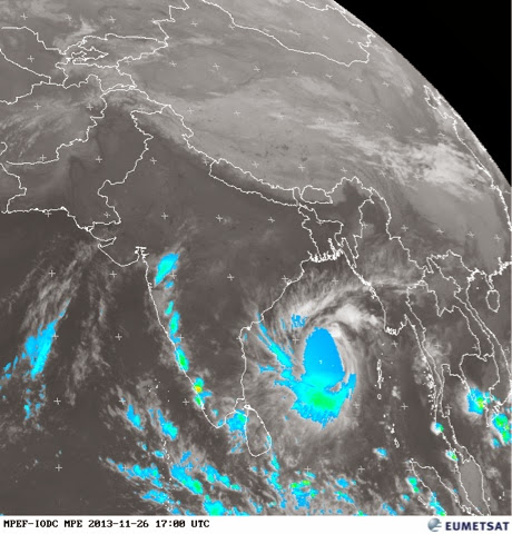
Severe Cyclone Leher brings rains to Goa - November end!

The severe cyclone Leher, currently located at 13 N and 89 E in the Bay of Bengal, is expected to make landfall as Cat 2 or Cat 1 strength cyclone in North AP on Thursday 28 afternoon.

But it's effects are being felt all along the west coast of India including Goa.

Today Tuesday 26th, the humidity was 92% in the early morning and 81% in the evening, representing +19% departure from normal. The Day high was 33.3 C and minimum 22.9 C.

Moderate to heavy rains are now lashing Goa since 9:30 pm.


Satellite imagery at 10 pm IST, showing clouding and rains along west coast of India, including Goa!

The evening rains may continue till the landfall of the cyclone on the east coast and stop as it fizzles over land.

Watch this space for more!

Tuesday, 22 October 2013

Cloudy, Rainy weather forecast from mid week

A rapidly developing low, strengthening east off the coast of Tamil Nadu together with a UAC developing into a low, off the coast of Karnataka and traveling northwards, are expected to together contribute to a fresh bout of off seasonal wet weather in Goa, mid week onwards from Oct 23 to 26th.


The above EUMETSAT image shows the position of the low on East coast as at 3 pm IST on Oct 22, bringing rains to TN and Andra coasts.

The IMD projections for Oct 25th as below, show the east blowing winds and the low centered at 15 N off the coast of Goa. 

This weather system is expected to bring the additional rains to Goa from 10 to 25 mm mostly on 23 rd evening, 24th and 25th.


The SW monsoon has completely withdrawn from the country and the NE monsoon has set. Rains in Goa associated with weather systems of NE monsoons in October are not uncommon.

Expect cloudy weather with occasional bouts of rains with high probability on 24, 25 and 26.

Posting from Chicago, USA, where first snows, freezing are expected on Oct 22!

Saturday, 19 October 2013

Withdrawal of SW Monsoon from Goa - Bye bye Rains, Hello Sunshine!

The easterlies have set in Goa, marking the withdrawal of SW Monsoon from Goa.


The IMD needs 3 days to officially declare the withdrawal, but even the official IMD map on October 19 indicates the withdrawal line at Goa's doorstep.


The days have turned hot, sultry and humid, leading to thunder laden conventional rains in the late afternoon in many parts.

Day Highs are 34C, with a feel of 40C under the sun.

The night Lows are around 24C.

Humidity is in the high 80s.

Late evenings and nights feel cooler, specially after shower bursts.

The weather will continue to remain hot over next few days.

I look forward to some dramatically different climes as I travel to the Mid west and North East US over the next ten days! Cold jet stream moving southwards from Canada is expected to lower the Highs to around 15C and Lows to near freezing in most of these areas. Would I see the first freezing or frost? I'm hoping I do!

Wednesday, 16 October 2013

Finally last gasps of SW monsoons 2013 - thunders a galore!

The SW monsoon is retreating rapidly now. Though IMD has not updated their withdrawal map, as of October 16, conditions in other parts of India indicate that monsoon withdrawal line could be at north Konkan running through MP.


The monsoon axis is shifting southward everyday and the monsoon is expected to withdraw from Goa by early next week.

Heavy thunder activity accompanied by moderate rains was reported from most places in Goa, specially in the interior after 2 pm.

Coastal areas were receiving scattered rains till late evening.

Skies were heavily overcast and humidity was high throughout the day.

Humidity recorded at 08:30 hrs was 89% (+05), and at 17:30 hrs was 88% (+13).

Thunder activity is expected to continue for next few days.

The day temperature is going to remain hot and sultry!

Saturday, 12 October 2013

Current weather in Goa

Rains have been sparse, 'hit and miss' across Goa.

Top rains recorded in the last two days in 24hrs period ending 08:30 hrs are:

Oct 11 - Old Goa - 12.5 mm

Oct 12 - Margao - 14.5 mm

It was dry in majority areas.

Day max temp is around 31.5 C
Night min temp is around 24.5 C

Humidy is in the 90s in the mornings and dew and fog are common at many places.

Humidity reduces into the 70s in the evenings.

A weak trough exists along the Arabian Coast, but rain activity will remain subdued till the depression reaches west traveling from the east.

Friday, 11 October 2013

Severe Cyclone 'Phialin' set to hit Odisha coast

The major typhoon 'Phailin' originating in Bay of Bengal and heading towards the coasts of Odisha and North AP, has rapidly intensified into a Cat 4 and is being classified as 'super cyclone' by IMD.

Core wind speeds are touching 250 kph and intense rains have started in the coastal areas of Odisha and North AP.


The cyclone combined with a UAC central India is expected to activate the trough in the Arabian Sea along west coast, which could bring squally weather and rains in Goa.