Showing posts with label Rains. Show all posts

Friday, 14 November 2014

November Rains - Updated November 16, 2014

Updated November 16, 2014

No rains reported in Goa on November 15. Sunday Nov 16 is sunny with clear blue skies. 

Updated on November 15, 2014 1430 hrs:

South Goa recorded more rainfall than North Goa in 24 hrs ending 0830 November 15. Some notable mentions:
Sanguem - 19 mm
Canacona - 17.6 mm
Margao - 12.6 mm (IMD)
Margao - 11 mm (Vagaries Goa)...

Sanquelim (N Goa) - 9.8 mm
Panaji - 3.3 mm


Posted November 14, 2014

Overcast sky conditions have prevailed in Goa for two days since November 13, under the influence of west coast trough extending from Gujarat to Kerala.

Light rains were experienced in all parts of Goa on November 14 from mid day onwards.

Panaji IMD recorded 3.3 mm between 0830 to 1730 hrs and Vagaries Goa at Margao recorded 2 mm during the same period.

Higher rainfall amounts were reported from interior Goa.

Due to the rains day's high temperature came down to 29.8C, 3 degrees below normal. However mornings continue to be warmer with 24.3C being 2 degrees above normal.

Skies are expected to clear over the weekend and no further rains are expected, along the coastal belt.


Thursday, 30 October 2014

Feels like winter is round the corner! Posted October 30, 2014


After months of hot and humid weather and the monsoon rains and then more rains, the morning of October 30 dawned with a sure promise of Winter round the corner, albeit Goa style!

October 30 morning recorded the lowest temperature of the month so far at 21.3C!

A lovely morning with cool winds, blue skies and soft sunshine.

It can only get better and cooler from here, for those of us who have had enough of the rains and the heat!!

The day highs will continue to be between 31-33 C for still some more days!

Cyclone Nilofar has rapidly downgraded to a deep depression at 1730 IST on October 30, from a category 4 cyclone within 36 hrs. It lay to the west south west of Kutch and is expected to bring some heavy showers to Kutch in Gujarat and Sindh in Pakistan. But these regions will be spared of any cyclonic threats.


For those desiring more detailed information on Cyclone Nilofar, please checkout the regular posts from Weather Guru Rajesh Kapadia at http://www.vagaries.in

Saturday, 25 October 2014

Heavy Rains Lash Goa - Cloud Burst over Margao! Posted October 25, 2014

Those who follow the frequent updates at Vagaries Goa's Facebook Page, will already be aware that the Deep Depression currently raging in the Arabian Sea off the Coast of Goa and which was expected to bring rains to Goa this weekend, has done just that and how!

The rains started all over Goa around 4 pm on October 24. The EUMETSAT image at 1830 IST clearly shows the developing cells over Goa and along the coast south of Goa:


It quickly became clear that Margao was getting more rains than anywhere else.

The Vagaries Goa Rain gauge at Margao was sprinting fast!

Rains started in Margao at 1630 hrs and within the first hour 33 mm were recorded. 72 mm were recorded within 2 and 1/2 hrs. The tally had climbed to 119 mm in 5 hrs till 2100 hrs, when the rains began to ease. Final tally for 24 hrs ending 0830 hrs on October 25 stood at 130 mm at Vagaries Goa. IMD's official reading at Margao was a tad lower at 122.8 mm.

Thus Margao recorded more rains in 12 hrs than in the entire month of October till date. Unfortunately past records are not available for Margao, but this must count amongst the all time maximum recorded on an October day!

In comparison Panaji recorded only 19.9 mm, while the next highest was recorded by Quepem at 60 mm and Sanguem at 57.5 mm.

The rains of October 24-25 in Margao  took the total tally for the month of October so far to 195.1 mm making it the wettest place in Goa in October so far! Sanguem was second at 182.4 mm and Valpoi third at 171.1 mm.

Rainfall recorded in 24 hours at 0830 hrs on October 25, 2014 (Source IMD)
 

Goa continued to be covered in thick clouds from the Arabian Sea disturbance throughout the morning of October 25, and Vagaries Goa recorded 25 mm rains till 1300 hrs. It was as if the June weather at the start of Monsoons had returned!


Margao at 0800 hrs on October 25, 2014
As explained at the Blog Vagaries of Weather in the latest post here,  scattered rains from the developing cyclone are expected to continue in Goa till Tuesday. The day highs may come down to 32-33C and lows to 25-26C.


Monday, 13 October 2014

SWM withdraws from Goa, October 13, 2014

The weather blog Vagaries of Weather has estimated that South West Monsoon 2014 has finally withdrawn from the Konkan belt, including Goa as mentioned in its  post on October 12 at http://www.vagaries.in/2014/10/posted-sunday-morning-severe-cyclone.html

Monday morning October 13 saw most of Goa enveloped in mild to thick fog. Goa may have seen the last of the thunderstorms this year on Saturday October 11. There were no reports of rain from any part of Goa on October 12 or 13.

While early mornings are humid, the hot winds have started blowing from N and NW during late mornings and afternoons. The day max temperature is set to cross 33C and will hover around 34-35C in the coming days as October heat from Winds blowing from the North begins to be felt.

The easterly blowing jet streams at 200 hPa have shifted below 15N and westerlies are now turning south as seen here:


However IMD's limit of monsoon withdrawal map still shows the SWM active below Mumbai on the west coast!


So finally the monsoon winds which reached Goan shores this year on June 11, 2014 have finally withdrawn on October 12, 2014! 

Monday, 29 September 2014

SW Monsoon is now withdrawing - posted September 29, 2014

The South west Monsoon has now started withdrawing from India beginning from west Rajasthan and progressively from Gujarat, west M.P., west U.P., The Punjab and the rest of the country.

IMD has officially indicated the withdrawal in the map below as on September 28.


Monsoon normally withdraws from Goa between Obctober 1 and 15. This year is no exception and during last two weeks Goa has been experiencing isolated thunderstorms in the late afternoons and evenings, typical of withdrawing monsoon.

The day maximum temperatures are expected to be around 33-35C with lower humidity than normal due to winds blowing from the East and North.

Monday, 22 September 2014

Likelihood of rains this week - posted Monday September 22, 2014

Goa continues to enjoy a fine mid September spell of occasional rains and plenty of sunshine as forecast in the last post !

However things may change later this week. Retreating monsoon season would see late afternoon and evening showers accompanied with thunder from Wednesday 24th onwards till around Friday 26th. This would be particularly true towards the hills in the interior of Goa. Coastal areas may experience overcast skies. As explained by the weather blogger Mr Rajesh Kapadia in his blog The Vagaries of Weather at http://www.vagaries.in  in THIS POST a Line of Wind Discontinuity (LWD) will form on 23rd from around Satara in Maharashtra to interior Karnataka, and a low will form at the same time in interior Karnataka. This low is expected to travel west and fizzle out in the Arabian Sea off the coast of North Karnataka.

Goa will be benefitting from the rains from this system!

Quoting further from the Blog Vagaries of Weather "Monsoon has withdrawn from west Rajasthan and Kutch and begin gradually withdrawing from Punjab and (rest of) Rajasthan by 23rd".

Goa has received normal rain with just 4% excess as seen in this graphic from http://imdgoa.gov.in


However overall deficiency for SWM 2014 over India remains -11%


Things are not expected to change much over rest of the monsoon season which officially ends on September 30!

Sunday, 7 September 2014

SWM 2014 a Review so far - posted September 6, 2014

The official South West Monsoon season in India lasts from June 1 to September 30. The forecasts for this year's SWM were grim, what with the possibility of La Nina being predicted to bring poor rains to the country.

We are now one week into September and with just three weeks to go before this year's SWM season ends, its worthwhile taking a look back on the SWM 2014 performance so far.

Weather Blogger Rajesh Kapadia has done just that and his blog entry dated September 6, 2014 at www.vagaries.in is reproduced in full below after the graphics below.

The graphics indicate that a super duper spell in late August across the length and breadth of India has brought the deficiency down to just -12% as on September 6. Most of the country has received Normal rains, while J&K and S.I. Karnataka have received excess rains. Orange colour indicates deficient rains. There are no sub divisions with scanty rainfall records as on September 6, 2014! However the situation can change if the rains take a break for a few days in September!


Till September 5, NW India was the worst performer followed by East & North East and Central India. Punjab, Haryana, H.P. and Delhi NCR along with Marathwada remain the worry areas. However the excellent rains in Karnataka as a whole, has helped South Peninsula to show a deficiency of just -5%!

For Goa the situation is much better as on September 6, than what it looked like earlier. June '14 end the deficiency was -49%, July '14 end the deficiency was -17%, but by September 6, 2014, Goa had received +4% more than normal LPA, mostly due to the extremely heavy spell in the last week of August!


As the article by Rajesh Kapadia reproduced below indicates we may have a better year than 2009 after all!

SWM 2014 thus far. An brief Review....6th September - By Rajesh Kapadia (www.vagaries.in)

From a threatening -47% down to -12% today. The country has received 655 mms against a normal of 765 mms till date. Thats the overall All India Monsoon Position. Thanks to massive rains in Jammu Kashmir and Punjab last few days, the overall deficit has come to almost reasonable and "civilised" levels.In fact, a few more % points reduction and the dubious label of "drought" will be wiped out. IMD considers a drought year if the deficit falls below -10%. Seems likely to be covered this year.
India normally receives 890 mms in the 4 months of SWM season as a long term average.
Situation is far better than the worst year 2009. That year, the deficit at the end of the season was -23%.
But, still there are a few areas of concern. Punjab, UP and Marathwada amongst them. I would put it like this: the situation in these few regions is still far from being "drought free".Marathwada may see very good rains next few days from BB-8.
However, thinking positively, the late surge of rains in Punjab and Rajasthan and NW India, will benefit the rabi season immensely. It will be saturating the soil with sufficient soil moisture.

But, the water position may not be as comfortable. The overall water reservoir stocks is below normal,except in Central India. North ndia, which has seen the maximum shortage of adequate rainfall, sees the stock of reservoirs at 79% ( 93% last year) of full capacity. Eastern India stocks show 68% (75% last year) of full capacity. Western India 70% (76%) of capacity and South India 68% (81% last year. Central India is the lone zone seeing better than last year levels at 74% (58% last year).
The Overall country average is 71% ( 87%) of capacity against full level.

Thursday, 28 August 2014

A Wet Ganesh Chaturthi 2014 - Updated August 28, 2014

Monsoon has become vigorous over Goa since last three days and will continue to remain very active with very heavy to heavy downpour over the next three days coinciding with the popular Festival of Ganesh Chaturthi from August 29 to August 30th!

A low has formed in the Bay of Bengal off the coast of North AP / Odisha around 17N and under its influence the monsoon trough has become active in the Arabian Sea off the West Coast. This low is expected to track westward over land as a strong UAC, bringing rain to most parts of India.


The IGES/COLA forecast for the next fifteen days indicates very heavy rains on the west coast till 5th September and reducing thereafter as indicated below:


The Daily rain chart for Margao Goa reflects the increase in rain since August 25th:


The weekly analysis by IMD Goa, for week ending August 27, 2014 clearly indicates the above normal rains this week, particularly in South Goa.


Over the Ganesh Chaturthi Festival Days of August 29 and 30, the days are expected to remain heavily overcast and most parts of Goa will experience 60 - 100 mm rainfall per day. The maximum temperature will remain between 25-26C and minimum will come down to 23C.

For regular updates checkout www.vagaries.in

Wednesday, 11 September 2013

Update September 11, 2013 - Thunderstorms?

As this post is being written, sounds of distant thunder can be heard. The skies are heavily overcast here in Margao since last two days, but very little rainfall. However some other parts of Goa have recorded higher rainfall:

Rainfall in Goa in 24 Hrs ending 08:30 hrs on September 11, 2013:


S.No.
Rainguage
Station
24 Hrs
Rainfall (mm)
Seasonal Total (mm) w.e.f  01st June
1
         Mapusa
002.8
2597.8
2
                Pernem   
 008.2
 3041.6
       3
       Ponda
004.1
3297.9
4
         Panaji
000.2
2462.3
5Ela (Old Goa)000.02901.9
6Sankhali002.23484.4
7
    Valpoi
Trace
4588.0
       8
         Canacona
080.8
  2695.4
9
          Dabolim
024.0
 2378.4
10
         Margao
005.4
2943.1
11
         Mormugao
048.2
2343.1
12
     Quepem
002.2
 2887.7
13
Sanguem
006.0
3783.3


The UAC from east which was expected to enter Arabian Sea through Goa, took a northward route and entered the Arabian Sea through south Konkan, thus sparing / depriving -depending on how you look at it!- Goa of heavy rains! Only Canacona, and areas around Vasco da Gama received heavy rainfall, as seen in the table above.

Panaji is still 3 inches short of reaching the century mark, while Margao has received 116 inches and Valpoi 181 inches.


The second half of September is expected to be wetter than the first half, as the trough on the west coast has become active again.

In the meantime, whenever skies clear Cumulus, Stratus, Altocumulus and Cirrus clouds put on a fantastic array of figures and colourful displays, so typical of September skies in Goa.

Dr Nandkumat Kamat, the noted scientist, sends in a particular formation of Altocumulus clouds, with which his 7 year old son Nachiketas, was so taken up, that he named it as 'Devachim Botam' - God's Fingers.


The CloudSpotter's Guide by Gavin Pretor-Pinney, the founder of the Cloud Appreciation Society, classifies these types of clouds as the 'mamma' cloud formation, named after Latin for 'Breasts', which appear on the underside of different cloud types and often look like a field of udders!
 
More than half of September is still to come, who knows what you'll be able to see in the skies?!


Saturday, 7 September 2013

The Rains arrive for Ganesh Chaturthi - as predicted!

As predicted, the rains reached the shores of Goa, albeit a day in advance!

After Nil or trace rains from September 1 to 6, most parts of Goa experienced heavy to moderate rains since early morning of 7th. Though the rains are expected to ease off during the day on 7th,Goa is forecast to receive heavy to moderate rains from 8th evening to 10th.

As pointed out by blogger Rajesh Kapadia in his blog Vagaries of the weather the trough off the west coast of India from Goa to Kerala has become active due to emergence 
of a low off the coast of TN. This low is expected to move west across interior Karnataka and into Arabian 
Sea off Goa by 9th or 10th. Thus bringing heavy to moderate rains to Goa.

The EUMETSAT image as at 6:30 am on September 7 is as below, clearly showing the activity off west coast.


Sunday, 28 July 2013

Update July 28, 2013 - No respite from rains till July end?

The monsoon trough off the west coast of India, is expected to get stronger under the influence of an Upper Air Circulation centered around Rajasthan over Monday 29 and Tuesday 30, bringing fresh rains to the northern parts of the west coast of India, including Goa, till July end.

Winds blowing from west at 30-40 kph, are expected to dump around 30-40 mm of rain per 24 hrs in most parts of Goa.


So expect 4-5 intense but short periods of rain, with long gaps in between! What we call as the 'Almyacho cho Paus'?

As on July 28, four rain stations in Goa - Valpoi, Sanguem, Sankhali and Ponda - have already recorded more than 100 inches of rain. Pernem is very close with 98.57 in. But the surprise is Margao with 93.13 in already! Nearly 16% more than the 70 in it normally receives by July end.

Our July end Analysis is sure to reveal major surprises!

Will Margao touch 100 in by July 31? Looks difficult. But who can say, if the current spell continue?


Saturday, 27 July 2013

Update July 27, 2013 - Dams & Reservoirs position in Goa, Good news!

The five reservoirs in Goa have all filled up earlier than usual, thanks to the abundance of rains in Goa in July.

The water level in the five Dams is as follows:

Sr        Dam                    Capacity mcm        Full Reservoir Level     Level as on 26/07/13
                                     (million  cubic meters)        (FRL) Meters                   Meters

1.    SELAULIM                 234.36                                41.15                         42.42

2.    ANJUNEM                   44.83                                93.20                          92.44

3.    CHAPOLI                     11.20                                38.75                         38.24

4.   AMTHANE                     5.97                                 50.25                         50.25

5.   PANCHWADI                4.47                                 26.12                         26.20

While Chapoli usually fills up by August, the heavy rains of July has ensured its early filling up.

Hopefully even the areas which chronically experience water shortage in Goa, and there aren't many of them, will have water supply in plenty this year!

Selaulim Dam, Sanguem (File Picture)

Anjunem Dam, Keri Sattari (File Picture)

Chapoli Dam, Canacona (File Picture)

Sunday, 21 July 2013

Update July 21, 2013 - Battered by Rain

In the 96 hrs period ending 8.30 am Sunday July 21, 2013, Goa was battered with continuous rains in almost all parts of the state.

Average 96 hrs Rainfall till 8.30 am July 21, 2013
During the last 4 days Panaji and Margao received nearly 60 mm (2.36 in) rain daily while Valpoi at the base of the western ghats received 112 mm (4.40 in) rain daily.

However Sunday July 21 has seen rains easing off. While the skies have remained heavily overcast, rainfall recorded in most parts of the state till 5.30 pm has been less than 10 mm from 8.30 am onwards. Rains have come in short intense bursts and are likely to continue rest of the evening.

However rest of the week, particularly 1st half, promises to be equally wet for Goa with rains in the region of 30 - 60 mm predicted per day, under the influence of a lowoff the coast of Orissa.


Goa (circled in red) along with rest of west coast of India is forecast to receive more than 200 mm rains during the period from July 21 to 28, 2013 as per this prediction by NCEP.

Rains have brought the temperatures below normal with Day temperature around 27C and night temperature around 23C. Humidity however if around 98%.

Friday, 19 July 2013

Weather in Goa - Will it Rain? Your Guide to online resources Part I

You may be having various reasons to want to know if rains are imminent in Goa. 

1. You may be a visitor planning your trip to Goa and looking forward to lots of sunshine on the beach! 
2. You may be a resident Goan planning an outdoor function and you don't want your guests to get wet!
3. You may be a businessman who doesn't want the rain to interfere in his planned activity, or,
4. You may be one those like me, who look forward to the rains not for any business gains but just because you believe that Goa is best during rains!

As Goa receives almost all its annual rains of nearly 3000 mm average in just four months of monsoon, you will have to seek advice from the weatherman for bright and sunny days, between June and September!

But fortunately help is at hand, even for those who don't care about or ahem, let's say who are blissfully ignorant of all the weatherman's mumbo jumbo!

So, in this post and the next post we will try to see just how you may be able to firm up your plans for Goa with the rains or without the rains!

In Part I, we will look at the Weather websites and Apps which give you ready-made information.

In Part II, we will look at more detailed online resources from India Meteorological Department, EUMETSAT, COLA specially dedicated to the monsoon.

First up though -:

Weather Apps and Websites:

There are n number of good weather apps for your desktop or your mobile on all the platforms which are easy to install and could give you fairly good information on current weather in Goa or predictions for the coming 7 days or even 10 days. Many have links to satellite imagery to satisfy your curiosity for visual proof of clouds or lack of them.

My favourite websites for weather are Accuweather and Weather Underground .

When you type Goa India or Panaji Goa India in the City search field and select it, you are presented with all the information you will ever need in a new window. Though Goa is a state and Panaji is its capital city, the data available on the web and shown as Goa weather, is for Panaji City. Both the websites show forecast for next few days besides satellite views. Unfortunately Radar images are not available for Goa because - there is no Doppler Radar in Goa for meteorological use!

I prefer the Accuweather website though because it gives daily, hourly - separately for morning, afternoon, evening and night - weekend, extended and monthly weather. Besides weather for nearby places, warnings and historical weather data is also available. The forecast section has allIndia forecast shown graphically and covers quite a number of things.


The Accuweather App sits on the right sidebar of my blog, showing the current weather conditions for Goa. Try clicking on the various buttons on the app and it will take you to Accuweather website!

Apps like Accuweather, Weather.com, Weather Live are available for all types of mobiles and smart phones and they pretty much do the same things!

In Part II we will look at the monsson related resources on the website of India Meteorological Department and some more!

Thursday, 18 July 2013

Valpoi Rainfall reaches the Century Mark!

Valpoi will reach the milestone of 100 inches of rainfall today July 18, within 48 days of the start of the monsoon season!

Rains in Goa has seen increased activity from Tuesday evening, with most places receiving 30-60 mm in the 24 hrs ending Thursday July 18, 8.30 am, except Valpoi (97.6 mm) and Ponda (90.4 mm). This brought Vapoi's total seasonal rain so far to 99.28 inches (2521.8 mm) just short of the century mark, which is sure to be surpassed today!

With Goa expected to receive 30-60 mm daily average rain till Saturday, and then tapering on Sunday, sunshine may be in rare supply! But this is normal for Goa in July. Five - six intense downpours and light drizzle, with more rains in the interior of Goa.
Rain forecast till July 20
Very interesting data for High Rainfall areas of India from June 1 to July 13, 2013 prepared by Pradeep John is available at the website of the blog vagaries of weather

According to data the top three places with highest rainfall in India till July 13, 2013 are:
1. Talacavery (Karnataka) - 3600 mm
2. Agumbe (Karnataka) - 3451 mm
3. Surabhi (Karnataka) - 3431 mm

Cherrapunji (Meghalaya) with 2663 mm was at the 17th place, mainly because NE India has received deficient rain so far!

Valpoi finds a mention on this venerated list at 55th spot, so take a look. Many more familiar place names from neighbouring states in the list too!

Monday, 15 July 2013

Monsoon Magic in Goa - Fun with numbers!

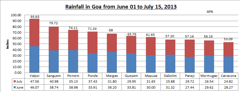
Just 45 days into the season and the Monsoon 2013 season is on way to break all records in Goa!

The season started on June 1, and the monsoon arrived in Goa with a bang on June 3, earlier than normal. Since then sunshine has been in rare supply!

There are 11 rainfall measuring centers maintained by India Meteorological Department, Goa (IMD, Goa) and what is normally taken as the rainfall for Goa is the reading of just one of these ie of the capital city of Panaji.

The magic figure everyone waits for is 100 inches of rainfall, Valpoi is already over 90 inches and Panaji nearing 60! Still two and half months to go!


The rain recorded in the first 15 days of July at 5 centres Valpoi, Sanguem, Ponda, Mapusa and Panaji, surpassed the rains received for the full month of June! And the other centres are not too far behind!
 
So by September 30, 2013:
1. Will Valpoi cross 250 inches?
2. Will Panaji and thus for the record 'Goa' reach 150 inches?
3. Will Ponda break into top three?
4. And will Margao finish above Panaji?

Watch this space!!